U.S. flag

An official website of the United States government

Earthquake Hazards Program

The USGS monitors and reports on earthquakes, assesses earthquake impacts and hazards, and conducts targeted research on the causes and effects of earthquakes. We undertake these activities as part of the larger National Earthquake Hazards Reduction Program (NEHRP), a four-agency partnership established by Congress.

News

M7.7 Mandalay, Burma (Myanmar) Earthquake

M7.7 Mandalay, Burma (Myanmar) Earthquake

USGS Seeks Earthquake Hazards Research Proposals

USGS Seeks Earthquake Hazards Research Proposals

The Night the Earth Shook

The Night the Earth Shook

Publications

Overview of The SCEC/USGS Community Stress Drop Validation Study using the 2019 Ridgecrest earthquake sequence

We present initial findings from the ongoing Community Stress Drop Validation Study to compare spectral stress‐drop estimates for earthquakes in the 2019 Ridgecrest, California, sequence. This study uses a unified dataset to independently estimate earthquake source parameters through various methods. Stress drop, which denotes the change in average shear stress along a fault during...
Authors
Rachel E. Abercrombie, Annemarie S. Baltay Sundstrom, Shanna Chu, Taka'aki Taira, Dino Bindi, Oliver S. Boyd, Xiaowei Chen, Elizabeth S. Cochran, Emma Devin, Douglas Dreger, William Ellsworth, Fan Wenyuan, Rebecca Harrington, Yihe Huang, Kilian Kemna, Meichen Liu, Adrien Oth, Grace Alexandra Parker, Colin Pennington, Matteo Picozzi, Christine J. Ruhl, Peter Shearer, Daniele Spallarossa, Daniel Trugman, Ian Vandevert, Qimin Wu, Clara Yoon, Ellen Yu, Gregory C. Beroza, Tom Eulenfeld, Trey Knudson, Kevin Mayeda, Paola Morasca, James S. Neely, Jorge I. Roman-Nieves, Claudio Satriano, Mariano Supino, William R. Walter, Ralph Archuleta, Gail Marie Atkinson, Giovanna Calderoni, Chen Ji, Hongfeng Yang, Jiewen Zhang

Introduction to the special section on improving measurements of earthquake source parameters

Earthquake source parameters such as magnitude, seismic moment, source dimension, stress drop, and radiated energy are fundamental to understanding earthquake physics, and are also key ingredients in earthquake ground‐motion modeling, rupture simulation, and statistical seismology. However, the uncertainties in these parameters estimated from the radiated seismic wavefield are large due...
Authors
Annemarie S. Baltay Sundstrom, Rachel E. Abercrombie, Adrien Oth, Takahiko Uchide

Increased flood exposure in the Pacific Northwest following earthquake-driven subsidence and sea-level rise

Climate-driven sea-level rise is increasing the frequency of coastal flooding worldwide, exacerbated locally by factors like land subsidence from groundwater and resource extraction. However, a process rarely considered in future sea-level rise scenarios is sudden (over minutes) land subsidence associated with great (>M8) earthquakes, which can exceed 1 m. Along the Washington, Oregon...
Authors
Tina Dura, William Chilton, David Small, Andra Garner, Andrea D. Hawkes, Diego Melgar, Simon E. Engelhart, Lydia M. Staisch, Robert C. Witter, Alan Nelson, Harvey Kelsey, Jonathan Allan, David S. Bruce, Jessica DePaolis, Mike Priddy, Richard W. Briggs, Robert Weiss, SeanPaul La Selle, Michael J. Willis, Benjamin P. Horton

Science

2025 Puerto Rico and U.S. Virgin Islands Long-term National Seismic Hazard Model

We anticipate the final 2025 PRVI NSHM to be available by December 21st 2025.
link

2025 Puerto Rico and U.S. Virgin Islands Long-term National Seismic Hazard Model

We anticipate the final 2025 PRVI NSHM to be available by December 21st 2025.
Learn More
link

Public kickoff webinar: 2026 National Seismic Hazard Models for Guam & Northern Mariana Islands and American Samoa

Monday, February 24, 2025 2:00-4:00 pm MST A Virtual Meeting
Learn More

M 6.9 October 17, 1989 Loma Prieta Earthquake

The 1989 Loma Prieta earthquake ended decades of tranquility in the San Francisco Bay region. It was a wakeup call to prepare for the potentially even more devastating shocks that are inevitable in the future. Since 1989, the work of the U.S. Geological Survey and other organizations has improved understanding of the seismic threat in the Bay region, promoted awareness of earthquake hazards, and...
link

M 6.9 October 17, 1989 Loma Prieta Earthquake

The 1989 Loma Prieta earthquake ended decades of tranquility in the San Francisco Bay region. It was a wakeup call to prepare for the potentially even more devastating shocks that are inevitable in the future. Since 1989, the work of the U.S. Geological Survey and other organizations has improved understanding of the seismic threat in the Bay region, promoted awareness of earthquake hazards, and...
Learn More

Multimedia

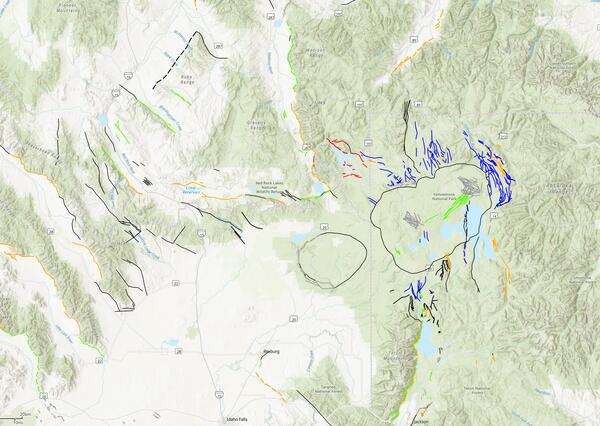
Snapshot of QFaults for the area including Yellowstone National Park
Seismic hazard model for Hawaii from 2021 showing peak ground acceleration where warmer colors are higher levels.
A cross section through the area of Anchorage, AK showing earthquakes at depths along with subduction model linework from Slab2 and inputs from the 2007 NSHM.
Alaska cross section from the 2023 NSHM
Shake Movie for M5.2 Julian earthquake Thumbnail Shake Movie for M5.2 Julian earthquake
Shake Movie for M5.2 Julian earthquake
man in front of a graphic for PAGER USGS PAGER during the Magnitude 7.7 2025 Mandalay, Burma (Myanmar) Earthquake
USGS PAGER during the Magnitude 7.7 2025 Mandalay, Burma (Myanmar) Earthquake
Aftershock Forecast Sequence-Specific Model Parameters
AftershockForecastSequence-SpecificModelParameters.png
An example of Bayesian updating of productivity parameter (a-value) for the 2010 Mw 8.8 Maule, Chile, earthquake. Immediately following the earthquake, the SZ-GENERIC region-specific a-value distribution can be used. As the aftershock sequence progresses and additional data are collected, this distribution can be treated as a prior distribution and updated using Bayes’ rule. Posterior distributions at subsequent time intervals are shown. Figure from Page et al. (2016).
AftershockForecastfig6.gif
Screenshot of the Aftershock Forecast for an earthquake in California, showing the information box at the top of the forecast and the four tabs of forecast information.
Mendocino_headerinfo-2.jpg
Equation 2 for the Aftershock Forecast probability distribution to compute the forecast
AftershockEquation2Screenshot.png
Was this page helpful?